


Gaynor Deacon is the Managing Director of Amaza Survey Services (Pty) Ltd; a South Africa based Hydrographic Consultancy Company. Established in 2018, in Kwa-Zulu Natal, South Africa, Amaza Survey Services is celebrating 5 years of delivering quality products with exceptional service delivery and a personal touch. Alongside this celebration is its principal Ms Gaynor Deacon, celebrating three decades of experience in the Hydrographic Survey Industry. She is a Registered Professional Surveyor with the South African Geomatics Council (SAGC) and Royal Institute of Chartered Surveyors (RICS). She is currently the Secretary of the Hydrographic Society of South Africa. Gaynor has a Mine Surveyors Certificate of Competency (MSCC) in Sea Mining from the Namibian Chamber of Mines.
With 30 years in the industry, Gaynor has acquired exceptional with proven record of experience as a Surveyor in the marine mining, offshore minerals, dredging and marine construction industries, she has worked in senior management roles and as Party Chief, Client Representative and Technical Lead with major players in the industry. She also has extensive operational field experience in Southern and East Africa and been involved on various projects throughout Sub-Sahara Africa including Angola, Namibia, DR Congo, Kenya, Madagascar, Cameroon, Mauritius, Malawi and Ghana.
Apart from ensuring a safe and efficient navigation across our seas, hydrographers play an important role of conducting and providing professional advice in relation to hydrographic surveys ensuring all hydrographic survey projects are a success to expectations. Africa Surveyors conducted an interview with Gaynor Deacon and she reveals of her 30 years of passion and still passionate about hydrography!
AS: Who is Gaynor Deacon?
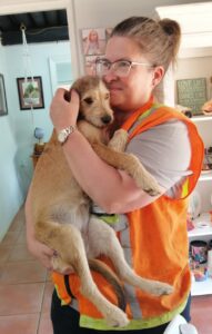
GD: I love my dogs and horses, enjoy travelling and am passionate about hydrography. Amaza is 5 years old and we are committed to providing our clients with quality, professional solutions and support with a personal touch.
AS: What motivated you to pursue a career in hydrographic surveying, and what specific aspects of the field are you passionate about?
GD: It all happened by accident – i was studying at college in Cornwall, UK and saw the degree advertised in a local newspaper so I applied and the rest is history. I changed my degree at the end of year 1 and focussed on Maritime Archaeology with hydrography playing an essential set of modules but it wasn’t my major focus, and I went on to do an Honours with a dissertation based on Maritime History. After I graduated and returned to South Africa I looked to pursue that field of interest but it’s even rarer than hydrography. I applied for a position as a hydrographic surveyor at a leading offshore diamond mining company and re-entered surveying albeit as a Sea Mine Surveyor. It was another 16 years before I surveyed a wreck – though in 2008 I was lucky enough to see the remains of a lost 16th century wreck discovered in the diamond fields of the Namibian desert. The best part of my career has been visiting different parts of the world, and going to places far off the usual tourist hang-outs. Its truly magical seeing the wildlife and untouched wilderness in the remote areas. Ive also been lucky enough to meet lovely generous people from all around the world, and learn about them and their cultures, and am humbled that they still send me birthday and holiday messages.
AS: 30 years ago when you dived into hydrography, what was the most challenging part of creating a successful and professional practice?
GD: Hydrography has always been very specialist and unique, so the challenge has been getting the training and experience, recognition, and accreditation. Opportunities on our continent are fewer – that being said the potential projects which require these skill sets are great, but traditionally larger international companies have been the main players. Personally for me, my career hasn’t always taken a conventional pathway, so its taken a little longer than normal but every survey, opportunity, posting and project has added invalueable experience and knowledge. With technology that has developed exponentially since the 90s, its such an exciting arena to be in and one has to be proactive and willing to keep abreast of these developments to compete and survive. To be successful one needs to be up-to-speed on the new developments, keep in touch with clients, listen to their needs and expectations, treat everyone with respect and offer a comprehensive, relevant and professional deliverable.
AS: You are assigned to conduct a hydrographic survey in an area with challenging environmental conditions and limited access. How would you plan and adapt your survey strategy to overcome these challenges and ensure data accuracy and safety?
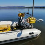
GD: Firstly clients need to be specific about what exactly they want to achieve from the survey, what the purpose of the survey is and what level of accuracy and resolution they need to fulfil their project specifications. They need to try and identify the area of interest so the survey can be planned accordingly. Today we employ remote sensing to assess the proposed survey area and use it for project planning. Where possible, new forms of remote sensing can acquire bathymetry in zones shallower than 5m where its not cost effective to use a multibeam and the resolution required is more than a singlebeam can provide. That being said, the field team will still do topographic and discreet survey lines into these zones for QA/QC and ground truthing. There are some nice portable high resolution multibeam survey systems on the market now, including the NORBIT family of sonars we sell and support and they are ideally suited for the remote areas where access is challenging and vessels of opportunity are few. This approach has greatly enhanced our clients’ operational deliverables as they fly in with a complete integrated solution which can be operated by one person, carry the gear as checked-in luggage, use satellite-based corrections when on site and PPK post-processing after, plus can use a smaller vessel (even canoes), and run the entire system off DC power. This shortens the duration of the whole project including mobilisation and commissioning, minimises the size of the survey team, reduces the time needed on site which all mitigates the risk to equipment and personnel, and importantly enables them to quote an attractive and competitive commercial offer.
AS: A client requests an urgent hydrographic survey to support the construction of a new offshore structure. How would you prioritize resources, plan the survey, and deliver timely and reliable data to meet the client’s needs?
GD: Amaza is uniquely placed to provide equipment and personnel from a network of local (sub-saharan) and international survey companies and service providers. We are familiar with the logistical and technical challenges in our region, and can provide invaluable advice and recommendations to save the client time and money. Due to our regions size and accessibility, the NORBIT portable system is ideal as its integrated design means the surveyor can fly in with a complete top-class multibeam system as check in luggage, mobilise on a local vessel of opportunity and complete the survey to IHO S-44 standards. This keeps the costs down to a minimum, and post-processing is done by a support team who work remotely with data uploaded to the Cloud. Remote sensing is another method used more frequently either in the form of satellite based corrections, aerial surveys and / or unmanned surface drones.
AS: At Amaza Surveys what training and certification do you have in place?
GD: We work closely with Skilltrade who has a recognised formal IHO/FIG/ICA CAT B course and a selection of other online short courses. We can also offer web-based hydrographic training on specific subjects and onsite hydrographic courses designed to meet the clients specific requirements, personnel competencies and equipment; Our principal trainer is a Level-0 accredited hydrographer Surveyor (IHO/FIG/ICA) has certification and registration with SAGC and RICS, and certification from a number of leading manufacturers. Through Amaza’s network, courses can be designed and developed with lecturers including academics, engineers and field operators. Amaza is a RICS regulated company and a corporate member of the HSSA which is a IFHS member society.
AS: How do you stay updated with the latest technological advancements and best practices in hydrographic surveying?
GD: I try and visit international conferences at least once a year and actively participate in the Hydrographic Society of South Africa (HSSA hydrosocietysa@gmail.com) which is a network of surveyors and people with an interest in hydrography. I am on the South African Geomatics Council as an Alternate Member representing hydrographic surveying locally and I read industry news online, trade magazines and newsletters. I also try and keep in touch with friends and colleagues in the industry via LinkedIn mostly and follow industry and manufacturer activities posted there.
AS: With 30 years in hydrography, what has been your greatest accomplishment?
GD: I’ve worked with some really hardworking and passionate surveyors, engineers and scientists, and am very proud and humbled to have played even a small part in their successes as they have gone on having amazing careers. “By celebrating other another person’s success like it’s your own, you grow stronger” (quote Anon). One can use it as inspiration and energy to keep moving forward. It’s truly a beautiful way to live because everyone gets to win. This idea is also expressed in Buddhism as “mudita”, meaning sympathetic joy or rejoicing in the good fortune of others.

