


Land surveying plays a crucial role in disaster risk management and resilience planning in Africa. By accurately assessing the terrain, mapping the land, and understanding the geographic characteristics of a region, land surveyors provide valuable data that can inform decision-making processes and help mitigate the impact of disasters. This article explores the critical role of land surveyors in disaster management and resilience planning in Africa, the challenges they face, and how collaboration between surveyors and disaster management professionals can enhance preparedness, response, and recovery efforts.
The Critical Role of Land Surveyors in Disaster Management and Resilience Planning in Africa
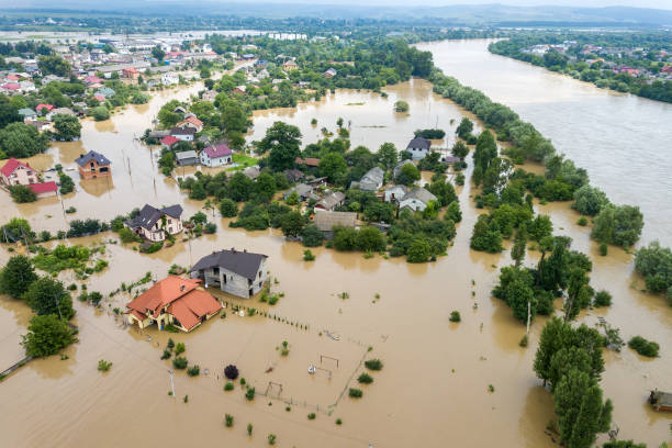
Land surveyors are responsible for collecting and analyzing data related to land and its features, including elevation, topography, and hydrology. This information is crucial for understanding the vulnerability of a region to natural hazards such as floods, earthquakes, and landslides. By accurately mapping the land, surveyors can identify areas at high risk and help develop strategies to mitigate these risks.
Furthermore, land surveyors play a vital role in post-disaster assessments. They can quickly assess the damage to infrastructure, identify areas that are safe and determine the suitability for reconstruction. Their expertise in mapping and spatial analysis enables them to provide valuable insights that inform decision-making processes during the recovery phase.
Challenges and Limitations of Incorporating Land Surveying in Disaster Risk Management Frameworks
There are several challenges and limitations that hinder land surveying’ effective incorporation into existing frameworks. One challenge is the lack of awareness and understanding of the value of land surveying in disaster management among policymakers and stakeholders. This often leads to insufficient funding and support for land surveying initiatives.
Another challenge is the limited capacity and resources of land surveying institutions in many African countries. There is a shortage of trained professionals, outdated equipment, and inadequate infrastructure, which hampers the collection of accurate and up-to-date data. Moreover, the lack of standardized procedures and protocols for land surveying in disaster risk management makes it difficult to compare and analyze data across different areas.
Enhancing Preparedness, Response, and Recovery Efforts through Collaboration between Surveyors and Disaster Management Professionals
To overcome the challenges and limitations, it is crucial to foster collaboration between land surveyors and disaster management professionals. By working together, they can enhance preparedness, response, and recovery efforts. Land surveyors can provide valuable insights and data that inform disaster management strategies, while disaster management professionals can ensure that surveying efforts align with the needs and priorities of the community.
Collaboration can take various forms, including joint training programs, information sharing platforms, and interdisciplinary task forces. Through these collaborative efforts, land surveyors can gain a better understanding of the specific requirements of disaster management, and disaster management professionals can benefit from the expertise and insights of surveyors. This synergy can lead to more effective and targeted interventions that safeguard communities and infrastructure.
Best Practices Showcasing How Land Surveying has Contributed to Resilient Communities and Infrastructure
Several case studies and best practices demonstrate the significant contributions of land surveying to resilient communities and infrastructure in Africa. One such example is the use of land surveying techniques in flood-prone areas. By accurately mapping floodplains and identifying areas at high risk, surveyors can help communities develop early warning systems, evacuation plans, and flood control measures. This proactive approach has proven to be effective in reducing the impact of floods and protecting lives and property.
Another example is the role of land surveying in urban planning and development. By conducting comprehensive surveys and mapping exercises, surveyors can provide valuable data on land use, infrastructure, and resources. This information is crucial for designing resilient cities and ensuring sustainable growth. Additionally, land surveying can help identify suitable locations for critical infrastructure such as hospitals, schools, and emergency shelters, ensuring that these facilities are accessible and resilient to disasters.
Harnessing Technology in Land Surveying for Effective Disaster Risk Management and Resilience Planning
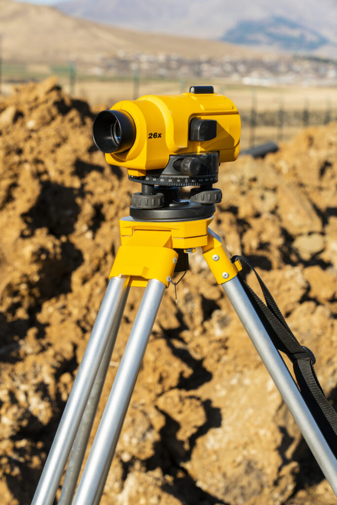
Technology plays a pivotal role in modern land surveying practices and can significantly enhance disaster risk management and resilience planning. Geographic Information Systems (GIS) and remote sensing technologies enable surveyors to collect and analyze vast amounts of spatial data, providing valuable insights into the vulnerability and resilience of a region. Drones and satellite imagery can be used to capture high-resolution images and create accurate digital elevation models, facilitating the identification of high-risk areas and the planning of evacuation routes.
Furthermore, advanced modeling and simulation tools allow surveyors to simulate various disaster scenarios and assess their potential impact on communities and infrastructure. These tools provide decision-makers with valuable information for developing effective disaster management strategies and allocating resources more efficiently. The integration of technology in land surveying not only improves the accuracy and efficiency of data collection but also enables real-time monitoring and early warning systems, enhancing the overall resilience of communities.
Training and Capacity Building for Land Surveyors in Disaster Risk Management
To ensure the effective integration of land surveying in disaster risk management, it is important to invest in training and capacity building for surveyors. Training programs should focus on equipping surveyors with the necessary skills and knowledge to assess the vulnerability of land to natural hazards, analyze spatial data, and develop effective mitigation strategies. Additionally, capacity building initiatives should address the lack of resources and infrastructure by providing surveyors with access to modern equipment, software, and data collection tools.
Collaboration with academic institutions and professional associations can help establish standardized curricula and certification programs that ensure the quality and professionalism of land surveyors. Moreover, mentorship programs and knowledge-sharing platforms can facilitate the exchange of best practices and expertise among surveyors, enabling continuous learning and improvement.
The Future of Land Surveying in Disaster Risk Management and Resilience Planning
The future of land surveying in disaster risk management and resilience planning is promising. Advancements in technology, such as artificial intelligence and machine learning, will further enhance the accuracy and efficiency of data collection and analysis. The integration of real-time monitoring systems and the Internet of Things (IoT) will enable surveyors to collect and transmit data in real-time, facilitating rapid response and decision-making during disasters.
Besides, the growing recognition of the importance of land surveying in disaster risk management and resilience planning will lead to increased support and funding for surveying initiatives. Governments and international organizations are starting to prioritize investment in land surveying infrastructure and capacity building programs, recognizing the long-term benefits of proactive planning and risk reduction.
Conclusion
Land surveying plays a critical role in safeguarding Africa’s future by contributing to effective disaster risk management and resilience planning. Despite the challenges and limitations, collaboration between surveyors and disaster management professionals can enhance preparedness, response, and recovery efforts. By harnessing technology, investing in training and capacity building, and sharing best practices, land surveyors can provide valuable insights that inform decision-making processes and protect communities and infrastructure. Safeguarding Africa’s future requires a holistic approach that integrates land surveying into disaster risk management frameworks, ensuring a resilient and sustainable future for all.
