


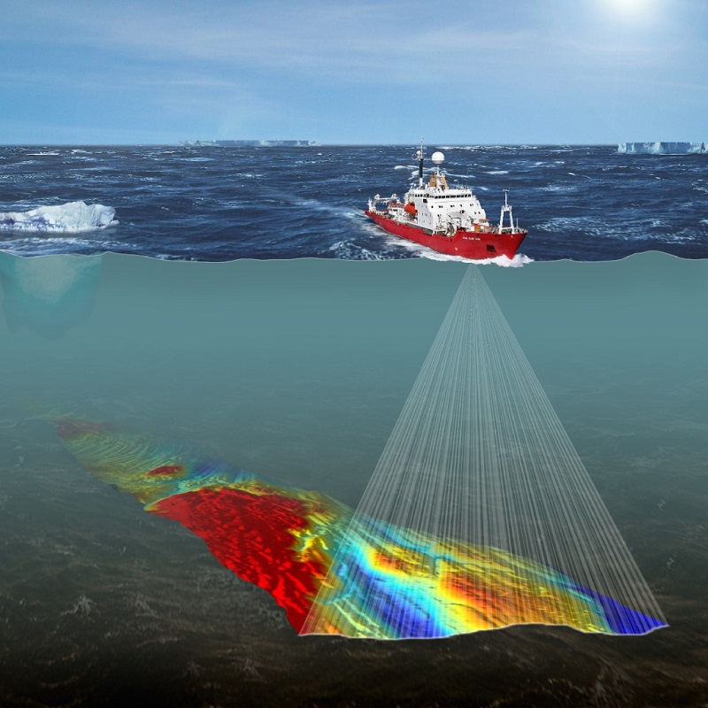
Hydrographic survey is the science of measurement and features description present underwater that affect maritime navigation, dredging, marine construction, offshore oil exploration/offshore oil drilling and related activities. Understanding why hydrography survey is important helps explain its use in these essential undertakings. Authority concerns oversee hydrography, which relies primarily on sensors, sounding methods, and electronic sensing systems for shallow-water surveys.
Hydrography maps the underwater bottom with a high level of accuracy, enabling the correlation and interpretation of data obtained from other methods that measure thickness from the seabed, generate sub-bottom information, and support quality checks of the results.
Because surveyors cannot directly observe or occupy the submerged surface, they infer topography from depth measurements by deducing underwater terrain from numerous discrete depth observations taken across the survey area. The activity uses the raw data collected through hydrographic survey into information usable by the end user. However, the quality of its product depends on the accuracy and density of these observations. But why is it important to keep under water features and measurement in check?
Importance of Hydrography
Ships and fishing boats use hydrographs to establish whether an area is safe to head into, either in advance or while on the water. It is important to obtain the underwater measurement and description of the physical features of oceans, seas, coastal areas, lakes and rivers, as well as with the prediction of their change over time, for the primary purpose of safety of navigation and in support of all other marine. While the objective is to delineate the shape of a portion of the earth’s surface concealed by water, practitioners place strong emphasis on soundings, shorelines, tides, currents, seabed conditions, and submerged obstructions, as these elements directly support the activities described above.
Navigation
According to Jennifer Birdsall, Seafloor Systems Inc. Marketing Coordinator, Hydrographic Survey serves an extremely important function due to its inherent association with ocean going vessels. To ensure that large vessels fully laden with petroleum products pass unobstructed and undamaged through navigational channels and canals, surveyors must conduct highly accurate surveys on a consistent basis.
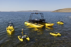
Seafloor Systems has a wide dealer network in Africa as well as extensive users in the Civil Construction and Mining industries. Their Seafloor USV and Echosounder products have found use in Egypt, Mozambique, Morocco, South Africa, and Zimbabwe.
Accuracy
In his opinion Sean Strevens of Cheetah Marine Says that, hydrographic survey is done to obtain accurate river and coast data to allow safe shipping and mining.
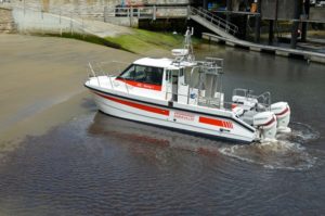
Cheetah Catamarans are renowned in the commercial world where time at sea is dictated by the weather conditions a boat can operate in. The company sells direct to their customer from their factories in the UK and Portugal.
Dredging
Regional Sales Manager at Teledyne Marine, Nico van Woerkom says that, doing Hydrographic surveys on cm level accuracy helps one to know the depth of the Port/rivers and one can easily determine where dredging should take place or if dredging is required.
”Knowing the exact depth can save millions of dollars on maintenance. Inspection of breakwaters using our multibeam technology is also an essential part of the surveys,” says van Woerkom.
Teledyne Marine is a group of leading-edge subsea technology companies within Teledyne Technologies Incorporated. Their products support port operations for dredge maintenance and surveys, enable river applications for measuring water flow and discharge, and facilitate hydrographic surveying.
Total cost / budget control
“Hydrography originated to ensure safe travel to seafarers and prevent grounding, saving thousands of life. Hydrographic survey became one of the principal pillars supporting the growth of countries having access to maritime and fluvial trade routes,” says David Vincentelli, iXblue, Manager at the Sea Operation division.
“It is therefore the baseline for any development of the African blue and green economy, supporting the development or the extension of ports, fairways, allowing new touristic development or lowering the cost of exporting raw materials or manufacturing goods. Not only supporting the economy, it is also one of the key science to understand the impact of extreme climate events and the impact of climate changes in general,” he adds.
iXblue offers a complete range of products, solutions and services for hydrographic, oceanographic, geophysical survey and marine environmental assessment in any African countries and any region.
Their products are widely used across Africa, including in Cabo Verde, Morocco, Seychelles, Réunion Island, Mauritius, Senegal, Tunisia, Gabon, Madagascar, Egypt, Eritrea, Angola, Algeria, Libya, Kenya, and Tanzania.
Delineating Maritime Boundaries
As a Hydrographic Surveying expert, Raphael Pacot, Deparentis Managing Director, believes that, Hydrographic surveying is essential on several levels. At the national scale, a good awareness of the situation makes it possible to assert one’s rights by delineating maritime boundaries, and thus to claim the natural resources in national waters, fishing, oil and gas.
Close to the coasts, hydrographic survey allows the control and maintenance of accesses, waterways, ports, to ensure safe navigation. The stakes here are vital. It should be remembered that more than 95% of international trade in Africa transits by sea.
Pacot adds that, the hydrographer’s expertise is essential for every construction project, maritime works, and installation of outfalls, power cables or telecommunications such as fiber optics, coastal development or erosion control.
Based in Dakar, Senegal, DEPARENTIS specializes in coastal hydrographic activities, inland navigation and port related services in West Africa. The company carries out investigations at sea from survey vessels specifically designed and equipped for this purpose. They are also involved in topo-bathymetric surveys on the coastline with LiDAR or photogrammetry.
Factors to consider when conducting Hydrographic Survey
Safety
According to Deparentis, safety is the first consideration as the activities involve exposure to water environment and conditions for which one must prepare: training and anticipation are the keys to safe practice. Technically, the project requirements are obviously those of the customer. However, there are international standards and norms, which are published by the International Hydrographic Organization (IHO).
“We have to adapt our capabilities and methods to meet a wide variety of needs. For example, a bathymetric survey takes different forms depending on whether it is a question of calculating dredging volumes, producing an accurate chart of a port or a navigational area, or carrying out a coastal protection survey over several kilometers of coastline. We cannot require our clients to master norms and standards, or to be informed of the latest state of the art. This is why we owe them the advice that is an essential part of our business, so that we can finally deliver the best service: the one they need,” says Pacot.
Mr. van Woerkom adds that, hydrograpic survey is essential to ensure safe shipping on rivers, channels and Ports.
Stability and Effeciency
According to Mr Strevens, When conducting hydrographic survey, the key factors to look out for is the vessel stability, fuel efficiency and easy engine maintenance.
“Another factor to consider is the Hydropod for the multibeam systems and if it does not need re calibrating between survey sites,” he adds.
Environmental Conditions
When it comes to environment conditions, Seafloor Systems suggests one of the main factors to consider when conducting hydrographic survey are the environmental conditions, and what data set you’re looking to achieve.
Conferring with iXblue perspective, there are several other factors that contribute to a successful hydrographic survey, this are:
– Vicinity of port and local support (crane, warehouse)
– Availability of vessels, crews or potential local surveyors
– Custom process for foreign manpower and imported equipment
– Permitting
– Local knowledge (expected water depth, geology, weather risk…)
Other factors include:
-Labor cost,
-Equipment cost
-Transportation
-Efficiency
-Acuracy & result
-Easy to operate or not
This is in respect to Frank Kong, the Project Manager for OceanAlpha Group Limited.
Oceanalpha manufactures Unmanned Surface Vessel/Autonomous Surface Vehicle. The company helps professionals in, water sampling, hydrography survey, patrol & drowning rescue. Their products are in use in Africa as well in countries like South Africa, Mozambique, Ghana, Nigeria, and Morocco.
The maintenance
Frank Kong, of OceanAlpha says that, as per the standard of different equipment, including physical and software maintenance, there is need to comply with operation procedure as per different equipment ‘ requirement.
Regular calibration procedures
Hydrographic survey equipment is generally robust, and operators primarily maintain it through regular calibration procedures and continuous signal quality control. Today, a wide range of equipment is available, from low-cost plug-and-play systems with short life cycles to fully auto-calibrated, durable systems designed for long operational lifespans.
“I would say the major maintenance procedure that is common to any hydrographic survey equipment is the field operators education background and continuing education. All major equipment manufacturers and hydrographic offices or regional hydrographic societies have developed or are developing e-learning capacities, webinar or other continuing education materials,” continues David Vincentelli from iXblue, and also president of the Francophone Hydrographic society.
Proper cleaning
Like all equipment deployed in the field in extreme environments, proper maintenance, operation and care is critical to the long term availability of the equipment. With hydrographic survey equipment, you have the added influence from salt water which requires proper cleaning and maintenance, this is according to Jennifer Birdsall of Seafloor Systems Inc.
Training
Mr. van Woerkom of Teledyne concludes that, training Hydrographic surveyors is key as this will help the surveyors know how to use the equipment correct and how to achieve best accuracies for data collection, data processing, modelling can do volume/differential calculations.
Read More:

