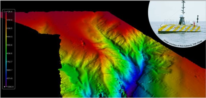
Teledyne CARIS, a Teledyne Technologies [NYSE:TDY] company, was an integral part of the illustrious team involved in the ground-breaking uncrewed offshore survey mission in the Atlantic Ocean. Teledyne CARIS’ Mira AI and CARIS Onboard software were present on the vessel to enable autonomous survey and real-time processing operations. The mission’s Uncrewed Surface Vehicle (USV) built by SEA-KIT mapped over 1000 sq kms of the ocean floor in 22 days, while being continuously monitored via satellite communications at its Remote Operations Center in Essex, United Kingdom. A specialized team comprised of the GEBCO-Nippon Foundation Alumni Team operated the survey equipment and provided quality control of the data from various ‘work-from-home locations’ around the world.
The SEA-KIT USV surveyed a predominately unsurveyed area at the southwestern edge of the UK Continental shelf. The image displays the initial results following a fully automated processing workflow. Final processing is currently being completed using CARIS HIPS software to produce the final deliverable for the survey.
The success of the Teledyne CARIS tools in the UTAS project demonstrates its software capabilities to support uncrewed surveys in the future and the crucial role it will play in The Nippon Foundation-GEBCO Seabed 2030 project. Seabed 2030 is an ambitious effort between GEBCO and The Nippon Foundation to complete the global mapping of the ocean floors in the next 10 years.
“Teledyne CARIS is uniquely positioned to underpin Seabed 2030 goals through its AI capabilities, web services and automated data processing workflows,” said Andy Hoggarth, VP, Sales and Marketing at Teledyne CARIS. “The success of this first leg is a tribute to the strong leadership of SEA-KIT and the unique capabilities and insights of all of the member organizations—we are delighted to play a part in this mission.”
Teledyne CARIS is part of the Teledyne Imaging group. For 40 years, Teledyne CARIS has been the leading developer of marine mapping software. We offer a highly effective solution for near real-time processing, robust quality control of sonar data, and the creation and distribution of maps, charts, and digital datasets.
Teledyne Imaging is a group of leading-edge companies aligned under the Teledyne umbrella. Teledyne Imaging forms an unrivalled collective of expertise across the spectrum with decades of experience. Individually, each company offers best-in-class solutions. Together, they combine and leverage each other’s strengths to provide the deepest, widest imaging and related technology portfolio in the world. From aerospace through industrial inspection, scientific research, spectroscopy, radiography and radiotherapy, geospatial surveying, and advanced MEMS and semiconductor solutions, Teledyne Imaging offers worldwide customer support and the technical expertise to handle the toughest tasks. Their tools, technologies, and vision solutions are built to deliver to their customers a unique and competitive advantage.
ALSO READ: Teledyne Marine Announces New Features Released for the Teledyne RESON SeaBat T-Series


